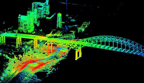

The USGS is using a new technology to 3-D map urban flooding from Hurricane Isaac. The technology is terrestrial lidar (LIght Detection And Ranging) and it will be used in a few urban areas in Louisiana, Mississippi, and Alabama to record the extent of the wind and water damage caused by the storm.
T-lidar collects data by bouncing light off surfaces and measuring the distance by the time it takes to return to the measurement device. Within four or five minutes of scanning, the lidar collect millions of data points in 360-degree view. The measurements are accurate up to a millimeter and can map areas up to two-thirds of a mile away.
The USGS will gather information on high water levels, elevations, and locations in order to better study the impact of the storm in three dimensions.
You must be logged in to post a comment.