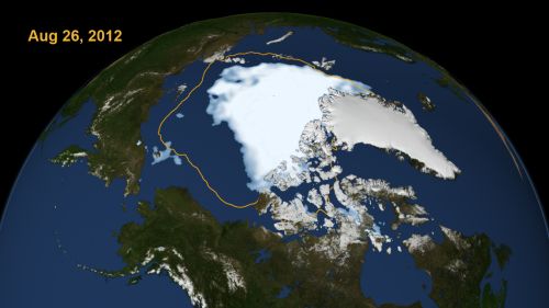

Arctic sea ice shrank to its lowest recorded level in the more than thirty years of satellite images. This visualization from NASA shows the extent of the sea ice on 26 August 2012. The yellow line shows the average minimum level of the sea ice for the years 1979-2010.
The difference is quite striking. The previous sea ice minimum record was set in 2007 at 1.61 million square miles of ice. The yearly loss of permanent sea ice (ice that doesn’t melt each summer) is contributing to the increasing loss of ice cover in the Arctic. The massive storm that settled over the Arctic earlier this month didn’t help any.
On 26 August 2012, the sea ice covered 1.58 million square miles – 27,000 square miles less than the 2007 record minimum.
Will the melting of the Arctic sea ice raise sea levels? No. The ice is already in the ocean. However, the Greenland ice sheet and other glaciers around the world are also melting. That will raise the ocean level.
The Arctic has a few more weeks of melting before cooler fall temperatures set in.
Image courtesy of NASA
You must be logged in to post a comment.