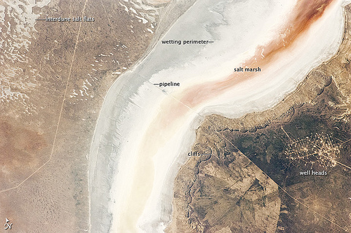

Sor Kaydak is a salt marsh on the northeastern side of the Caspian Sea in Kazakhstan. A one- to two-meter high bar of land separates the marsh from the sea, but occasionally the water from the sea spills into the marsh.
Here is a description of the photo from NASA:
Irregular gray areas (top left) are wet zones between low sand dunes. These inter-dune flats are whitened with salt that comes from the evaporation of Caspian Sea water. (The Sea is just beyond the top left of the image.) The jagged line following the colored water is the limit of the wetting zone (or perimeter), an irregular zone influenced by wind and the depth of water in the marsh.
Small cliffs mark the eastern margin of the depression that contains Sor Kaydak. Above the cliffs, a plateau—about 200 meters above the salt marsh, 160 meters above global sea level—extends eastward for hundreds of kilometers. Here the plateau is occupied by a dense pattern of well heads, which appear as a geometric pattern of tan dots. By contrast, the west margin (image left) rises less than 10 meters above the marsh.
The straight line visible at image center is a pipeline built to take oil to a terminal on the Caspian shore 100 kilometers northwest of the area shown here.
Photo by NASA Earth Observatory
You must be logged in to post a comment.